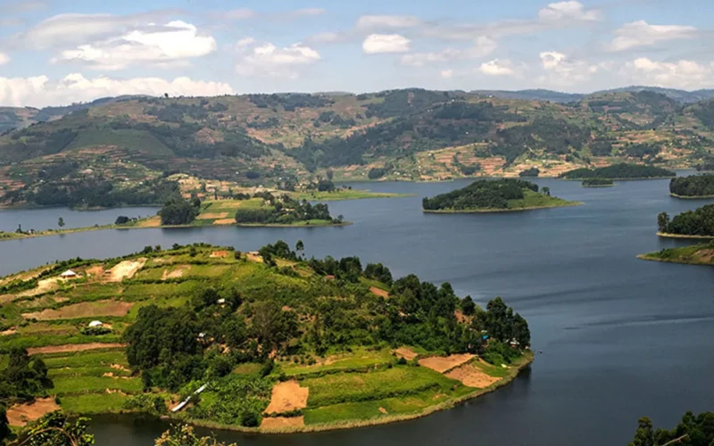
Lake Bunyonyi, nestled in the terraced highlands of Kigezi in the south-west region of Uganda is the second deepest lake on the continent boasting stunning landscape setting unlike any other attraction in the region. The picturesque island-dotted Lake Bunyonyi is a popular getaway destination for adventurers and holiday-seekers alike that seek to explore a vast of activities here. The scenic lakesides and surrounding hillsides are dotted with a wide range of excellent accommodations making Bunyonyi a popular base for mountain gorilla trekking experiences where the trailheads of Ruhiija and Rushaga in the UNESCO heritage site of Bwindi Impenetrable Forest lie 40 km or 2hr drive away. The montane park of Mgahinga Gorilla NP with its towering volcanoes lie about 2.5hrs south-west of Lake Bunyonyi.
Lake Bunyonyi Overview
Hemmed in the towering highlands, Lake Bunyonyi winds up for 25 km long to cover a surface area of 60km2. Lake Bunyonyi is a lava dammed lake formed 8000 years ago when hot lava flowing from Virunga Mountain Ranges blocked the Ndego river. It’s varying depths range from 40m-100m.
Bunyonyi which translates as “a place of little birds” in the local Bakiiga direct derives from the abundant birdlife that occur along the papyrus fringed lakesides and the heavily cultivated hillside edges.

Activities to do and Attractions while at Lake Bunyonyi
Lake Bunyonyi, lying 8 km south of Kabale town is an adventure hotspot offering a wide range of watersports, hiking expereince and cultural immersion activities in the midst of scenic and charming picturesque landscapes. These various activities can be explored from as short as 2 hrs to full-day adventure tour and include;
-
Canoeing, Abseiling and Swimming
While here at Bunyonyi, take an adventure experience to tour several historical islands using a local dug-out canoe the same the locals use everyday to access their gardens, markets, schools across the mainland or islands. On this experience you will paddle along a local guide showing you traditional paddling techniques on these quite lake waters and also pointing historical islands and birdlife on the lake edges. Better still you can opt to paddle alone without the local guide depending of course on one’s experience and ability to navigate the quite waters of Lake Bunyonyi. Canoeing experience lasts anywhere between 2-3hrs.
The waters of Lake Bunyonyi are bilharzia free and safe for swimming but caution must be observed as this is the second deepest lake on the continent with extreme depths.
-
Explore the Historical Islands
Take a ride in a local dugout canoe to explore several islands and learn about the rich history attached to these sacred islands. Of interest is the tiny Punishment island where in past, pregnant unmarried girls were left abandoned as this was a taboo in this complex culture. On tour here, visit the leprosy island where in the early 19th century was used as quarantine and treatment center for leprosy. Leprosy gone and forgotten, the large island now houses a church, school and hospital.
The twice-in-week market (Mondays and Friday) at the lake shore is a great place to take a stroll for its color, various merchandise and people.
-
Hiking Experience around Lake Bunyonyi
A mini-hike around the island dotted Lake Bunyonyi offers the most stunning landscape views anywhere in Uganda. The terraced highlands that hem in Lake Bunyonyi, rise over 2500m of altitude providing excellent hiking and walking opportunities lasting anywhere between 2 to 6 hrs depending on one’s time. Led by local community guides, the trek follow trails used daily by locals as they go about their daily lifestyles. This provides first-hand interaction to learn about the livelihood of the humble lakeside communities. Onwards into the community, you can opt to visit the local women groups as they engage into small social income generating initiatives like crafts and weaving. On a hike, visit the active local herbalist home and learn the richness and effectiveness of African medicine whose knowledge has been passed on from generation to generations treating majorly every disease. The medicine man is highly respected and revered in African culture as he not only treats diseases but also has ability to predict the future community he serves.
The hike continues on to several peaks of these towering highlands that rise up to 2500 m asl for excellent panoramic views of Lake Bunyonyi with its numerous islands.
Level of Difficulty
The terraced hillsides around Lake Bunyonyi rise up to 2500 m asl and one needs average fitness to do it. Various hikes follow everyday-used community trails and pose no serious difficulty to many unless one has altitude related complications as these hills rise between 2000m and 2500m asl otherwise the views are rewarding.
What to carry and Dress Code on a trek
- Good hiking/walking shoes
- Long pants as the trail passes through the community.
- Carry a rain jacket
- A hat and sunglasses
- Drinking water on that day.
- A good attitude
-
Birdwatching
The papyrus and marsh edged shores of Lake Bunyonyi offer a rewarding birding expereince where you encounter a wide range of high-altitude wetland specialists. Day trips target the most sought-out species include Papyrus Yellow Warbler known from a small patch of papyrus on the western edges of the lake, but White-winged Swamp Warbler, Grosbeak Weaver, Blue-headed Coucal, Lesser Swamp and Greater Swamp Warblers occur. Highland Rush Warbler occur in more luxuriant vegetation with Chubb’s and Winding Cisticolas among others.
The highly cultivated hillsides and farms attract Grey-crowned Crane, Grey-backed Fiscal, Streaky Seedeater, Common Stone-chat, Black-crowned Waxbill, Baglafecht, Spectacled, Horub’s and Little Weaver occur. The eucalyptus plantations host Cinnamon-breasted Bee-eater, African Harrier-hawk, African Goshawk, Long-crested Eagle, Augur Buzzard and more.
